
Wetlands & the buffer zones
Two wetland systems shape what can happen on and behind the lots: Kelleher Pond to the south/southwest, and the intermittent stream with its bordering vegetated wetland along the eastern boundary at the Beverly Regional YMCA. Around each, state law and Beverly’s ordinance draw concentric regulated bands — and several recorded conditions ride on them forever.
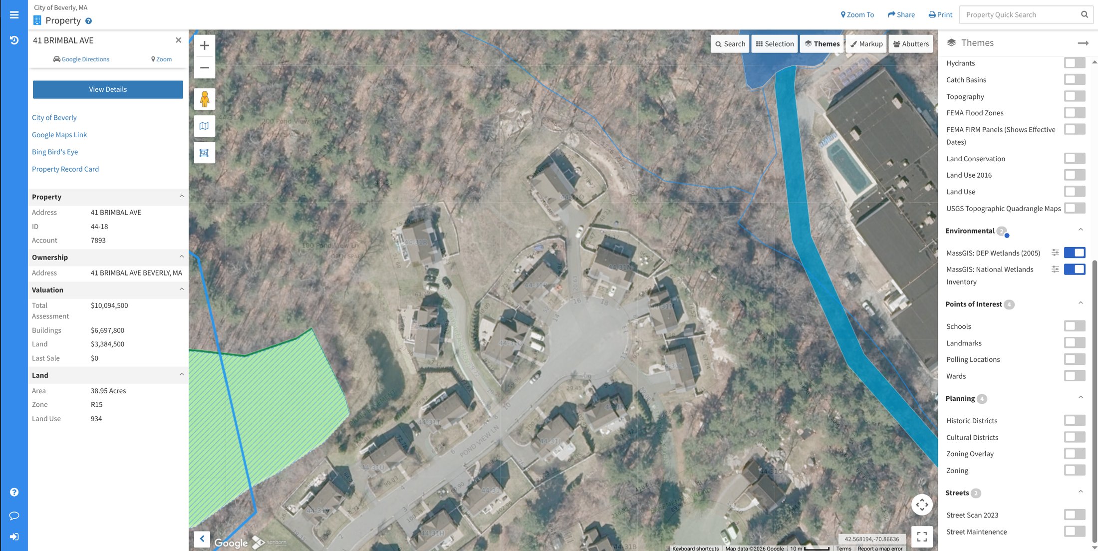 The mapped corridor (blue) — the intermittent stream and bordering vegetated
wetland — runs along the neighborhood’s eastern edge. Kelleher Pond is a
separate resource area to the south/southwest, off-frame.
The mapped corridor (blue) — the intermittent stream and bordering vegetated
wetland — runs along the neighborhood’s eastern edge. Kelleher Pond is a
separate resource area to the south/southwest, off-frame.
Source: Beverly MapGeo, the City’s public
parcel viewer, with the
MassDEP Wetlands
layer on. MassGIS states the caveat plainly: those boundaries are
photo-interpreted and “do not represent, and should not be used as, wetlands
delineations under the Massachusetts Wetlands Protection Act.”
The three bands
Section titled “The three bands”How close an activity is to a wetland resource area determines what review applies:
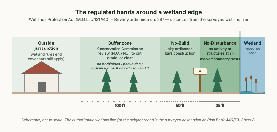 A drawing of the bands the sources below establish — not itself a record.
| Band | Distance | Effect | Source |
|---|---|---|---|
| Commission jurisdiction | within 100 ft | Cutting, grading, or clearing needs Conservation Commission review — an RDA or a Notice of Intent | M.G.L. c.131 §40 · 310 CMR 10.00 · Beverly ordinance ch. 287 |
| No-Build Zone | within 50 ft | City ordinance prohibits certain construction — stricter than the state act | Beverly ConCom FAQ · Wetlands Protection Regulations |
| No-Disturbance Zone | within 25 ft | No activity or structures at all; drawn on the recorded plan, with marked boundaries | ConCom FAQ · recorded plan, Sheet 8 · Order of Conditions ¶3, p. 16 |
The authoritative wetland line is the surveyed one — wetland flags WFB2–WFB16 on Sheet 8 of the recorded plan (the delineation traces to a 2009 survey confirmed by a Commission Order of Resource Area Delineation). GIS screening layers, including the maps on this site, only approximate it.
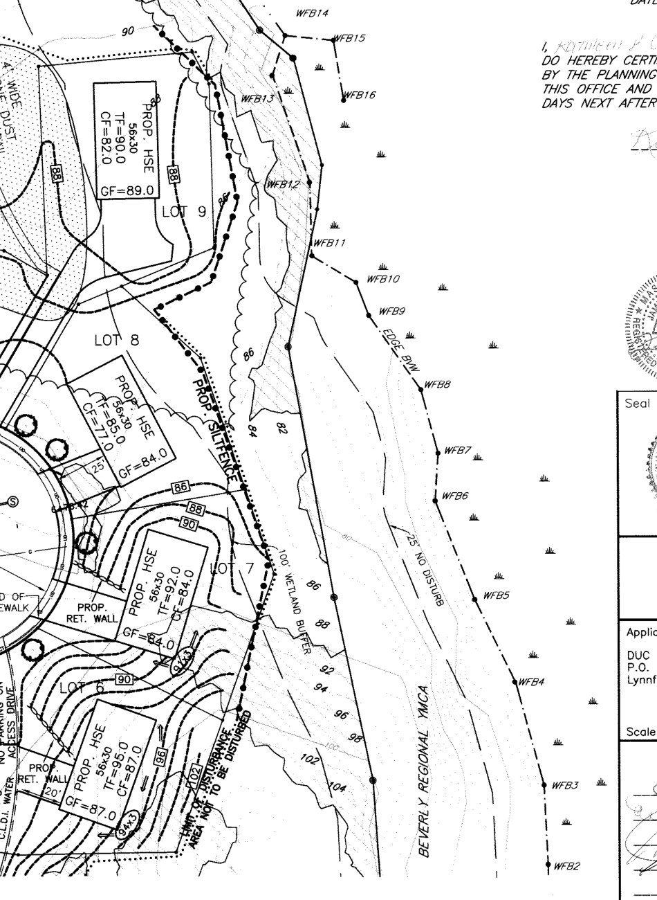 Sheet 8 of the recorded plan: the surveyed flag line with the 100′ buffer
and 25′ no-disturb lines running through the open-space strip behind the
upper cul-de-sac (recorded Lots 6–9).
Sheet 8 of the recorded plan: the surveyed flag line with the 100′ buffer
and 25′ no-disturb lines running through the open-space strip behind the
upper cul-de-sac (recorded Lots 6–9).
Source: a detail of Plan Book 446, Plan 73,
recorded at the
Southern Essex District Registry of Deeds — the
full 11-sheet plan is in the library, and the Registry holds the original.
Which lots the buffer touches
Section titled “Which lots the buffer touches”The 2014 Order of Conditions’ findings list the recorded lots containing wetland resources and/or buffer zones: Lots 7, 8, 9, 13, 14, 15 & 16 (Findings, p. 13). In street numbers, that’s #13, #18, #16, #8, #6, #4, and #2 (recorded Lot numbers and street numbers don’t line up — the crosswalk is in Finding the records). For those homes, part of the rear yard is likely inside the 100-foot band.
Rules that ride on the bands, forever
Section titled “Rules that ride on the bands, forever”From the recorded Certificate of Compliance’s perpetual conditions (pp. 4–5):
- No herbicides, pesticides, or fungicides within 100 feet of the wetland (¶5) — this includes lawn-care products on the rear of the buffer-zone lots.
- No sodium-based ice or snow products within 100 feet (¶6).
- No dumping of leaves, clippings, or refuse in resource areas (¶4).
- No snow storage in resource areas or buffer zones (¶2).
- The 25-foot No-Disturb markers — “No Disturbance Of Any Kind Beyond This Point By Order of the Beverly Conservation Commission” — must be maintained in perpetuity: the ones on recorded Lots 15 and 16 by those homeowners, the one at the mitigation-area bend by the association (¶1).
Planning work near the line
Section titled “Planning work near the line”It has been done right on this lane, start to finish. In 2021 a homeowner planning a fenced, terraced lawn area inside the buffer hired a wetland consultant (Seekamp Environmental), filed a Notice of Intent (June 2021, DEP File #5-1341 — about 600 sq ft of grading, with the wetland roughly 30 feet below the yard), and revised the plan once in response to review. The Commission heard the NOI on July 13, 2021 and issued the Order of Conditions the same evening, 4-0 (minutes excerpt · the City’s full 7/13/2021 minutes). The work was built to the approved plan, and on an as-built survey and a staff site visit finding the site stable and compliant, the Commission issued a complete Certificate of Compliance on August 2, 2022 — file opened, permitted, built, closed (minutes excerpt · the City’s full 8/2/2022 minutes). Roughly a year of process for a permanent, fully legal yard.
The other paths have also been walked. In late 2021, already-completed patio construction and landscaping at a home on the lane came to the Commission by an after-the-fact Request for Determination of Applicability: at a December 7, 2021 special meeting the Commission reviewed the permeable construction and the 50-foot No-Build line and granted a Negative 3 Determination with conditions, 4-0 (minutes excerpt · the City’s full 12/7/2021 minutes) — retroactive approval is possible, but it runs through the same review, on the Commission’s terms. And in 2024–25 the Commission enforced against unpermitted structures on the common parcel itself (7/1/2025 minutes). The pattern is consistent: file first. The Conservation Administrator (listed on the Commission’s page) holds the subdivision’s file and is the point of contact for “do I need a filing?” questions. An RDA is a short form with a modest fee; a Notice of Intent with a consultant is the fuller path for real construction — and retroactive enforcement is costlier than either. Every meeting cited above is on the public record: agendas and minutes for every Commission meeting are posted at the Beverly Agenda Center, and the subdivision’s own MassDEP wetlands file (#5-1127) can be pulled from EEA ePLACE.